

Mountbatursunrisetrekkin.net. Know Mount Batur as the mother of Mount Agung -Information from Batur Geopark Museum in Penelokan, Kintamani written if Bali located in the ring of fire, so it is not surprising there are many volcanoes on the island.
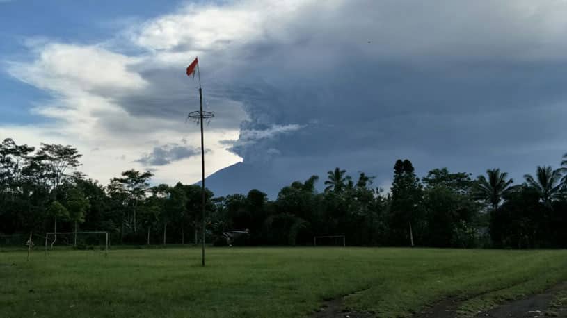
Know Mount Batur as the mother of Mount Agung ( Take from Bangli while eruption on 27th November 2017)
Two of them are Mount Batur and Gunung Agung which have the privilege for the people of Bali. Both mountains are considered as a phallus or natural that has significance for Balinese people.
Mount Agung is considered the manifestation of Purusha (male) and Mount Batur is considered as a Pradhana (female). Between Purusha and Pradhana cannot be separated because it always synergizes to give birth to fertility and create prosperity for the community.
Devi Kemal Syahbana said, Mount Batur is one of the ancient mountains in the island of Bali. Its existence is older than Mount Agung whose status eruption since November 2017 till today December 2017. According Devi Kemal Syahbana, the two mountains have a close, it can see from Batur Geopark Museum in Penelokan, Kintamani. The first one is Mount Batur, so it can be said if Gunung Agung is the son of Mount Batur
Since prehistoric times, the people believe that mountains, hills, and higher places are sacred places where the spirits of ancestors and other centers of natural forces are located. This can be seen from the direction of dealing with sarcophagus or corpse without container. The direction of the face or the location of the head of the corpse mostly leads to the nearest hill or mountain.
Mount Batur is located in Kintamani, Bangli, Bali and became one of the tourist attractions visited by tourists. In the east slopes of Mount Batur there is nested a lake with the same name of Lake Batur is located in a high area, which is 1037 meters above sea level with an area of 16 km square with an average depth of 78 m.
From Batur Geopark Museum data explained, if the first eruption of Mount Batur started in 1804. When it formed the main crater of Batur volcano, 17 years later, precisely in 1821, a second eruption took place from the same crater. In 1849 there was an eruption from the main crater and produced a lava flow to the south up to the edge of the lake. 1994-1995 Mount Batur erupted many times, the next eruption occurred in 1997, 1998, 1999, and latest in 2000 where ash come up till 300 meters above the peak.